THE SOCIALIST REPUBLIC OF VIET NAM
Government News
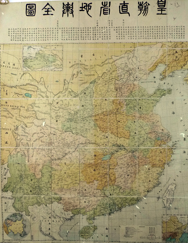
Paracel, Spratly not on China’s official map
VGP – The Map of all Chinese provinces reveals that China stretched as far south as Hainan Island, thus Paracel and Spratly archipelagos did not belong to China.
 |
|
The Map of all Chinese provinces of Qing Dynasty |
It’s a color-coded paper map that has a carton-paper cover and can be opened like a book. Inside the map, there are more than 35 pieces – each measured at 20cm wide, 30cm long.
The map was distributed to all provinces of the Qing Dynasty, the last imperial dynasty of China ruling from 1644 to 1912. The introduction of the map was written by the director of a Chinese observatory.
Dr. Hong presented the Map of all Chinese provinces to the Vietnam National Museum of History on July 25 for preservation and display.
According to historian Duong Trung Quoc, Vice Chairman of the Vietnam History Science Association, this map provides more authentic evidences to affirm Vietnam’s sovereignty over Paracel and Spratly islands.
After seeing the map, Dr. Susan Bayly from United Kingdom’s Cambridge University said Vietnam discovered a very new document which shows a clear scientific background.
By Kim Anh